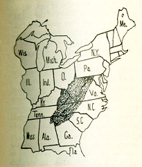
According to David Walls, William Goodell Frost, President of Berea College from 1892 to 1920, was “the first person to give a precise geographic definition to the Southern Appalachians as a cultural region” with the help of his former student, C. Willard Hayes, “then working for the Geological Survey.”
Though Frost’s text indicated that the region was 194 counties, county boundaries have shifted since 1896. Our ArcGIS recreation includes 195 counties as our best approximation of Frost’s hand-drawn map.
Walls, David. 1977. On the naming of Appalachia. In An Appalachian symposium: Essays written in honor of Cratis D. Williams, edited by J.W. Williamson. Boone, NC: Appalachian State University Press.
List of Counties | View Dynamic Map Individually | ArcGIS Shapefile | Compare and Contrast Maps